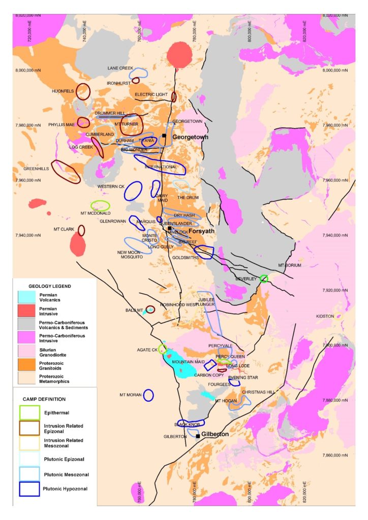
4.1 PROTEROZOIC METAMORPHIC AND INTRUSIVE ROCKS
Proterozoic rocks are dominated by the Paleoproterozoic Etheridge Group. The Etheridge Group includes compositionally diverse metamorphic rocks, subdivided into numerous individual units – Einasleigh Metamorphics, Cassidy Creek Metamorphics, Juntala Metamorphics, Bernecker Creek Formation, the Robertson River Subgroup (Daniel Creek Formation, Dead Horse Metabasalt, Corbett and Lane Creek formations), Upper Etheridge Group (Towneley, Hellman and Candlow formations, Lungdon River Mudstone) (Withnall, 1984; Bain and Draper, 1997; Jell, 2013).
The Einasleigh Metamorphics, dominant in the south and east of the region, are characterised by layered biotite and calc-silicate gneisses, with common amphibolites and migmatites. The Juntala Metamorphics, composed of mica schists (locally graphitic) and minor quartzites, grade into and are faulted against the Einasleigh Metamorphics in the south of the region. The Cassidy Creek Metamorphics, compositionally similar to the Juntala Metamorphics, are structurally juxtaposed against the Einasleigh Metamorphics in the east of the region (north-east of Einasleigh). The Bernecker Creek Formation consists predominantly of calcareous to dolomitic fine-grained sandstones, siltstones and mudstones, grading to the east into calcareous mica schists and quartzites with calc-silicate minerals and finally – calc-silicate gneisses, compositionally similar to parts of the Einasleigh Metamorphics into which the Bernecker Creek Formation proably grades.
The Robertson River Subgroup is mostly composed of originally fine-grained meta-sediments (calcareous siltstones, calcareous or carbonaceous mudstones, minor sandstones), interlayered with dominant meta-basalts with common pillow-lava textures in the Dead Horse Metabasalt. The stratigraphically higher Upper Etheridge Group is dominated by siltstones and mudstones (locally calcareous or carbonaceous), minor sandstones and rare thin limestones. The Langdon River Mudstone, the uppermost unit of the Etheridge Group, consists of laminated carbonaceous pyritic mudstones.
Depositional age of the Etheridge Group is constrained by U-Pb geochronology of magmatic and detrital zirons. The lower part of the Etheridge Group (including the Einasleigh Metamorphics, the Bernecker Creek Formation and the Robertson River Subgroup) was deposited between 1700 and 1660 Ma (Jell, 2013). The minimum age of the top of the Etheridge Group is constrained at ~1630 Ma by the maximum depositional ages (U-Pb on detrital zircons, Neumann and Kositcin, 2011) of the Langdon River Mudstone (1629 ± 12 Ma) and the Langlovale Group (1625 ± 5 Ma), which unconformably overlies the Etheridge Group along the western margin of the Etheridge Province (Withnall, 1984; Jell, 2013).
The Etheridge Group was intruded by extensive Mesoproterozoic predominantly S-type granitoids, mostly forming the Forsayth Batholith. The main individual plutons include the Aurora, Delaney, Forsayth, Goldsmiths, Mount Turner, Bowler Creek, Mistletoe, Ropewalk, Welfern, Mywyn, Mount Hogan and Lighthouse granites, the Forest Home and Talbot Creek trondhjemites and the Brandy Hot Granodiorite. U-Pb zircon geochronology indicates the major emplacement age of the Mesoproterozoic granitoids across the region at ~1550-1560 Ma (Black and Withnall, 1993; Bain and Draper, 1997; Neumann and Kositcin, 2011; Jell, 2013). The presence in the region of relatively common zircon cores in zoned magmatic zircons from Mesoproterozoic and Palaeozoic granites and sedimentary rocks with measured ages of ~1580 Ma (Murgulov et al., 2007; Kositcin and Bultitude, 2015; Kositcin et al., 2015) indicates an earlier event of magma emplacement or partial melting.


 and mineralisation related intrusions (lower section).")
