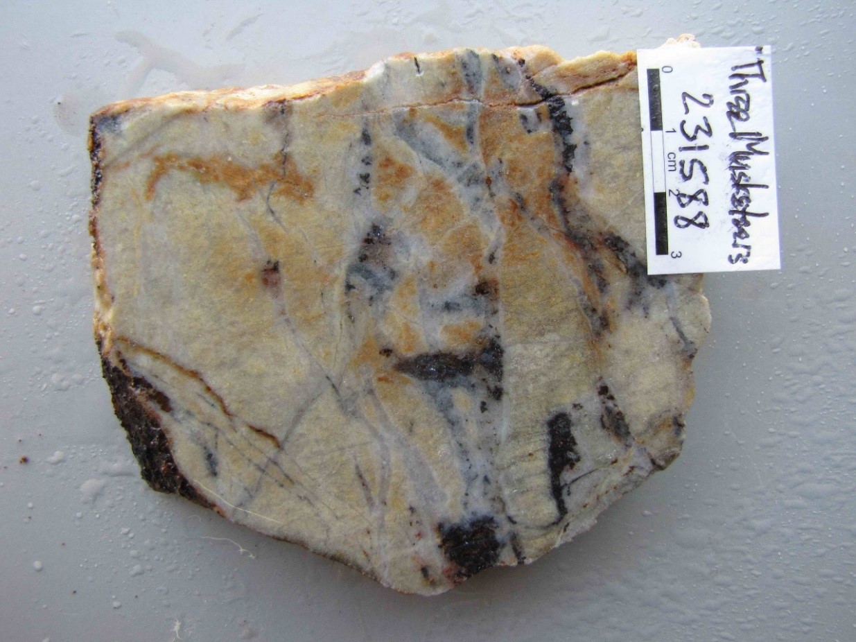
The style of mineralisation as stacked/en echelon quartz veins with prominent sericitic alteration envelopes in a 70m thick zone of partly mylonitic granite and quartz is typical of occurrences such as the Josephine mine and Mountain Maid prospect (Percyvale), Jubilee Plunger (Robin Hood), Marquis near Forsayth, Mt Clark and many occurrences at Croydon. The partly mylonitic form of the host structure implies meso-hypozonal conditions and is consistent with the quartz character and comparison with Devonian orogenic deposits in the province. Mt Hogan alteration has been dated at 400Ma at the mine and at 398Ma at the General Gordon vein deposit so this is internally consistent. The multi-element geochemical signature of prospects in the Mt Hogan camp is Te Au Ag Bi Pb and this is consistent across the gold prospects in the camp and similar to numerous camps along the eastern margin of the Etheridge-Gilberton fields such as Percyvale, Goldsmiths, Queenslander and Lighthouse.
METALLOGENIC STUDY OF THE GEORGETOWN, FORSAYTH AND GILBERTON REGIONS, Part 6

METALLOGENIC STUDY OF THE GEORGETOWN, FORSAYTH AND GILBERTON REGIONS, Part 5
August 19, 2019
METALLOGENIC STUDY OF THE GEORGETOWN, FORSAYTH AND GILBERTON REGIONS, Part 7
August 19, 2019METALLOGENIC STUDY OF THE GEORGETOWN, FORSAYTH AND GILBERTON REGIONS, Part 6
Report Number 114062, METALLOGENIC STUDY OF THE GEORGETOWN, FORSAYTH AND GILBERTON REGIONS, NORTH QUEENSLAND is now available for download from QDEX. The authors are Dr Gregg Morrison, Harry Mustard, Ashley Cody, Dr Vladimir Lisitin (GSQ), Jose Veracruz and Dr Simon Beams.
A collaboration between Terrasearch Pty Ltd, Klondike Exploration Services and the Geological Survey of Queensland, funded under the Queensland Government Future Resources Program.
TABLE OF CONTENTS
3.0……… GEORGETOWN MINE ENDOWMENTS and HISTORICAL GOLD PRODUCTION.
4.1 PROTEROZOIC METAMORPHIC AND INTRUSIVE ROCKS.
4.2 SILURIAN – DEVONIAN INTRUSIVE ROCKS.
4.3 LATE DEVONIAN TO EARLY CARBONIFEROUS SEDIMENTARY ROCKS.
4.4 PERMO – CARBONIFEROUS INTRUSIVE AND EXTRUSIVE ROCKS.
5.0……… THE METALLOGENIC DATABASE AND GIS.
6.0……… AGES AND EPOCHS OF MINERALISATION.
7.0……… MINERALISATION STYLE AND DEPTH CLASSIFICATION BASED ON QUARTZ TEXTURES.
7.1 QUARTZ TEXTURES OF PLUTONIC DEPOSITS.
7.2 QUARTZ TEXTURES OF INTRUSION RELATED DEPOSITS.
7.3 QUARTZ TEXTURES OF EPITHERMAL DEPOSITS.
7.4 QUARTZ TEXTURE ASSEMBLAGES AND CAMP DEFINITION.
8.0……… MULTI-ELEMENT GEOCHEMISTRY.
8.1 METHODOLOGY OF MULTI-ELEMENT GEOCHEMISTRY INTERPRETATION.
8.2 INTERPRETATION OF GEORGETOWN MULTI-ELEMENT GEOCHEMICAL DATA.
8.3 GEOCHEMICAL ZONATION PATTERNS.
9.1 MOUNT HOGAN flat plutonic lode.
9.5 KIDSTON INTRUSIVE RELATED MESOZONAL BRECCIA HOSTED GOLD DEPOSIT.
9.7 HUONFELS, INTRUSION RELATED EPIZONAL LODE AG – AU PROSPECT.
9.8 AGATE CREEK EPITHERMAL GOLD DEPOSIT.
10.0……. OVERALL METALLOGENIC CLASSIFICATION.
12.0……. GEORGETOWN EXPLORATION POTENTIAL.
APPENDIX 1 : GEORGETOWN METALLOGENIC CAMP SUMMARIES
APPENDIX 2 : GEORGETOWN METALLOGENIC Database
APPENDIX 3 : GEORGETOWN METALLOGENIC CAMP STRUCTURAL PLAN
APPENDIX 4: MAPINFO WORKSPACE PACKAGE – Georgetown Metallogenic Simplified Geology (zip)
9.0 DEPOSIT MODELS
Examples of the different deposit styles encountered in the Georgetown region are described, focussing on the nature of the quartz textures, geochemical signature of the mineralisation and the temporal and spatial relationship with any nearby intrusives.
9.1 MOUNT HOGAN flat plutonic lode
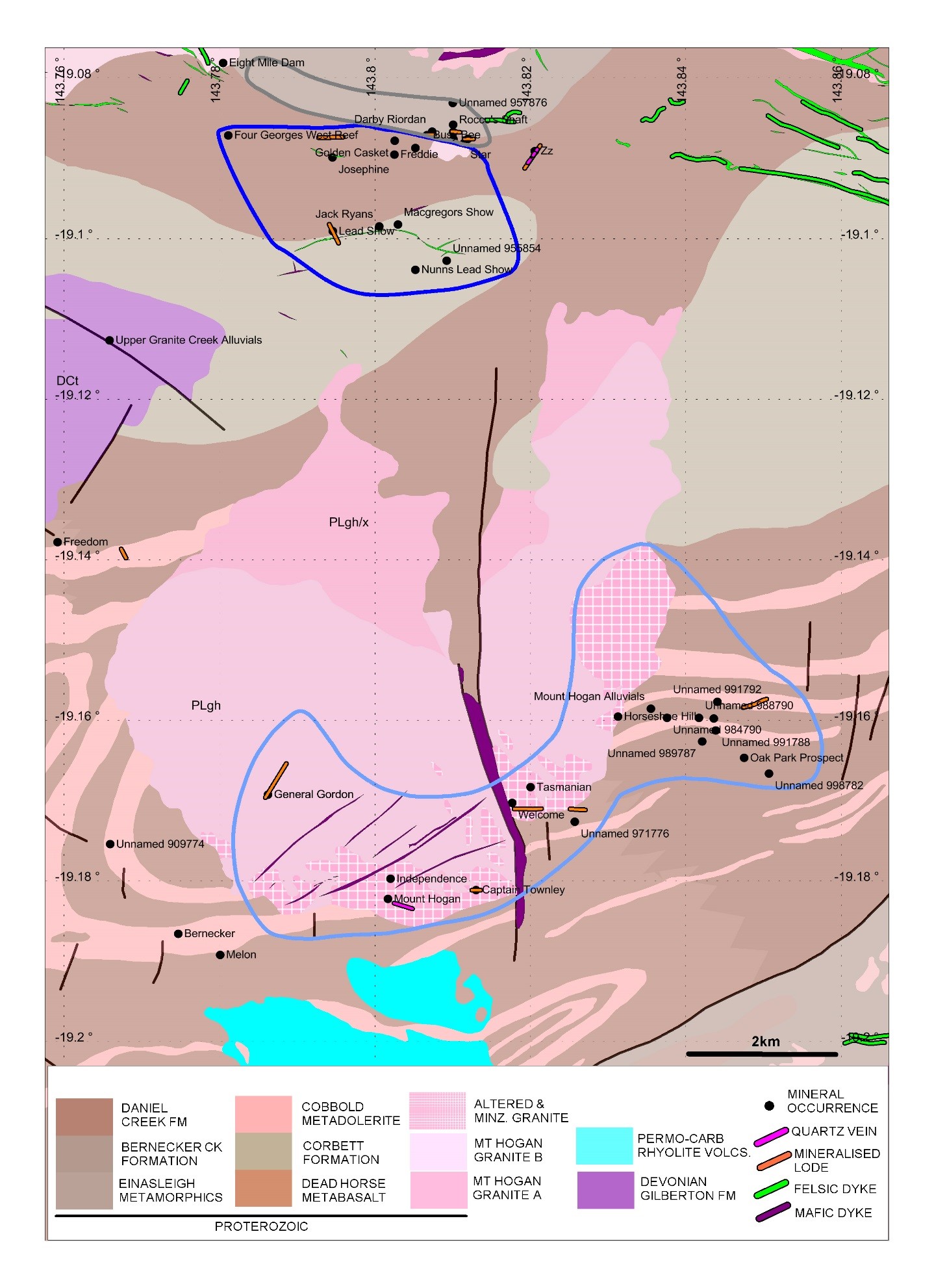
The Mount Hogan gold-base metal-uranium deposit is the largest historical gold producer in the Gilberton district at 2530 kg. The deposit is located 18kms northeast of Gilberton and is hosted in the Proterozoic age Mount Hogan Granite (Figures 1 & 6). The granite pluton is an irregular horseshoe shape in outcrop, 7kms in diameter and has intruded Proterozoic rocks of the Robertson River Subgroup (Figure 12). The granite is composed of grey (fresh) to pink (altered), medium to coarse grained, equigranular, sparsely porphyritic, biotite adamellite. Northern outcrops of the granite appear to be a less fractionated (more mafic) phase of the intrusion. Permo-Carboniferous rhyolite and andesite dykes have been mapped immediately north of the Mount Hogan gold deposit (O’Rourke & Bennel, 1977). Drilling at Mt Hogan suggests the southern contact between granite and the surrounding metasediment is near vertical.
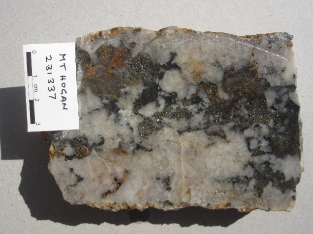
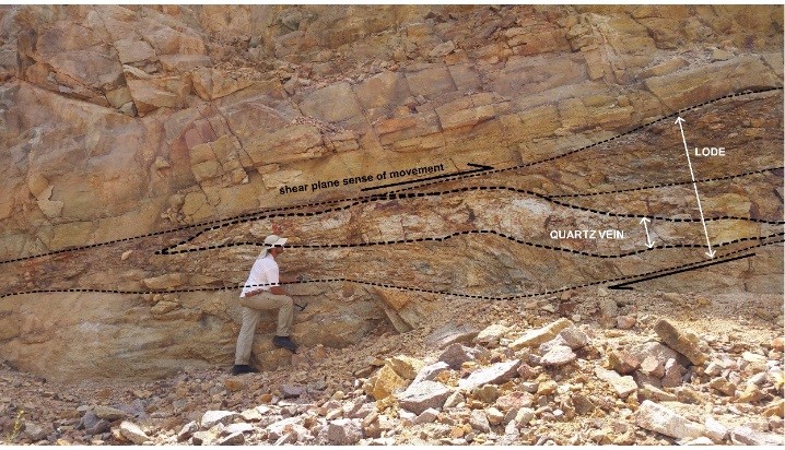
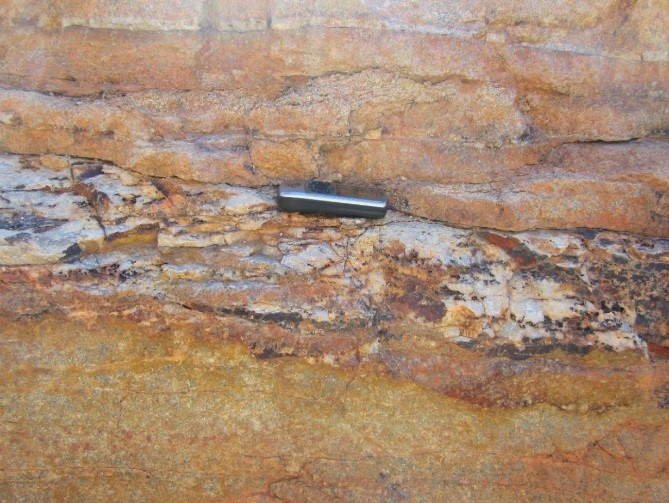
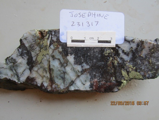
Gold mineralisation is concentrated around the south-eastern margin of the Mt Hogan Granite and consists of a set of stacked, shallow, southwest dipping (15-20˚) quartz – sulphide veins. The veins are composed of medium grained, euhedral buck quartz crystals that have been brecciated and recrystallised by later movement of the veins structures. Cores of the veins are often filled with sulphide (Plate 18). The lenticular veins are enveloped by an alteration halo of sericite (proximal), chlorite and epidote (distal) and appear to have developed in tensional openings produced by north-easterly thrusting. Continued movement along structures after vein formation has deformed and folded some veins (Plates 19 & 20). Individual veins reach up to 60cm in thickness but are generally thinner (10 – 20cm).
The alteration and by inference the quartz veins and shear zone are Devonian age (~400Ma) based on K-Ar radiometric dating on sericite. The nature of the mineralisation and host structures indicates the deposit is plutonic meso-hypothermal in style, the high bismuth and tellurium values point to the mineralising fluids having an intrusive source component however there is no clear genetic link to Permo-Carboniferous age rhyolite and basalt dikes in the general area.
O’Rourke and Bennell (1977) suggested there is primary uranium mineralisation as uraninite associated with the sericite alteration and the gold-base metal sulphide bearing quartz veins and in the fluorite veins that cut the rhyolite and basalt dikes. Secondary uranium, mainly torbernite is dispersed in the alteration zones and host rocks over a wide area at surface. The Horseshoe Hill uranium occurrence is in quartz stockwork and fractures in the Mt Hogan Granite. Drilling by Bondi Mining (Newcrest JV) in 2008, returned a best intercept of 7m @ 0.38% U3O8 (drill hole 79HHPDH1) with a metal enrichment of U Sb As Zn Ag Mo W (Pb Cu). The implication is the same as at Mt Hogan Mine with the primary uranium mineralisation being part of the gold event.[/vc_column_text]
9.2 PLUTONIC LODE DEPOSITS
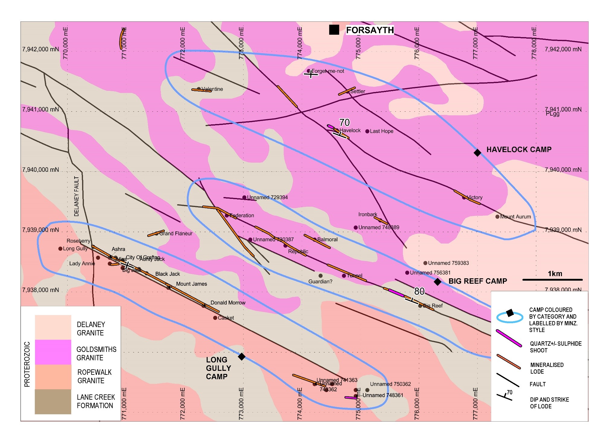
The Forsayth and Georgetown districts are well known for their lode or quartz reef style gold deposits. The deposits lie along steeply dipping well defined regional scale faults or their subsidiary structures hosted in Proterozoic granite and metasediment Fig 6 & 9. A greater proportion of deposits are hosted in granite which appears to deform in a more brittle manner and develop much more open space for mineral deposition compared to the metamorphic rocks where fault movement tends to be absorbed through ductile deformation. Structures like the WNW striking Big Reef – Goldsmiths Fault, Black Jack line of workings and Havelock Fault which lie south of Forsayth and the east-west striking Drummer Hill, Big Wonder and Golden Bar Faults near Georgetown range from 5 to 25 kilometres in length. All these structures are mineralised intermittently along their entire length.
The multiple phases of shearing, brecciation and quartz +/- sulphide mineralisation along the faults attest to the long history of movement and annealing along these structures. Zones of weakly mineralised sheared rock or lodes typically occur at regular intervals along the structures. Within the lodes, narrower (<2m) shoots of higher grade quartz +/- sulphides have been targeted by the historical miners. In some deposits the shoots are well defined and have not been disrupted too much by later movement along the controlling structure, allowing miners to follow the shoots continuously for hundreds of metres underground e.g. International and Big Reef (Figure 13). However, in some deposits mineralised shoots have been brecciated by later movement along the faults diluting the high grade material with lower grade wall rocks.
Most of the lode style gold occurrences in the Georgetown and Forsayth districts contain tightly packed, coarse to medium grained, buck quartz typical of Plutonic hypozonal or mesozonal deposits. However, many deposits show multiple events of brecciation and cementation and replacement by silica and sulphides and it is often the later, finer grained (higher level?) phases that are gold bearing (Plates 4, 10 & 15).
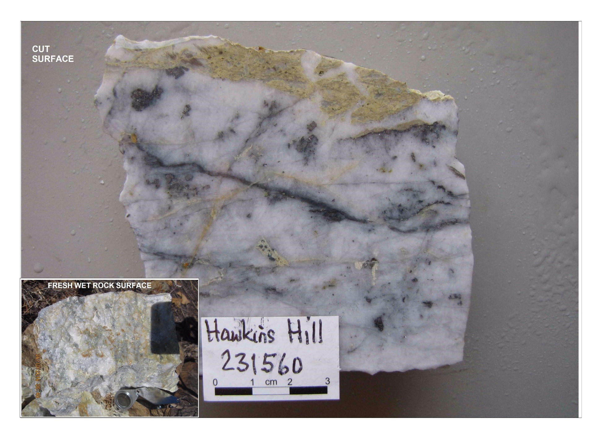
Inspection of numerous deposits in the field has shown that like the preferred granite host, early quartz reef development and silicification along the structures has provided extra preparation of the rocks providing potential for more sites of brittle deformation and formation of open space. Later phases of mineralisation in the lodes and shoots can be subtle. Outcropping, buck quartz reefs can be quickly passed off as barren but when smooth wet surfaces, preferably cut with a rock saw, are closely inspected, late stage, fine grained phases of often clear coloured quartz and sulphides can often be found (Plate 21).
Examination of the trace element geochemistry for the Plutonic style lode deposits shows that the occurrences in the cores of the districts are enriched in bismuth and tellurium whereas the peripheral deposits tend to be more silver and arsenic dominant (Figures 10 & 11). This zonation, observed at both Georgetown and Forsayth suggests the centre of the districts maybe closer to a magmatic fluid source and the peripheral deposits more distal.
9.3 GILBERTON DISTRICT
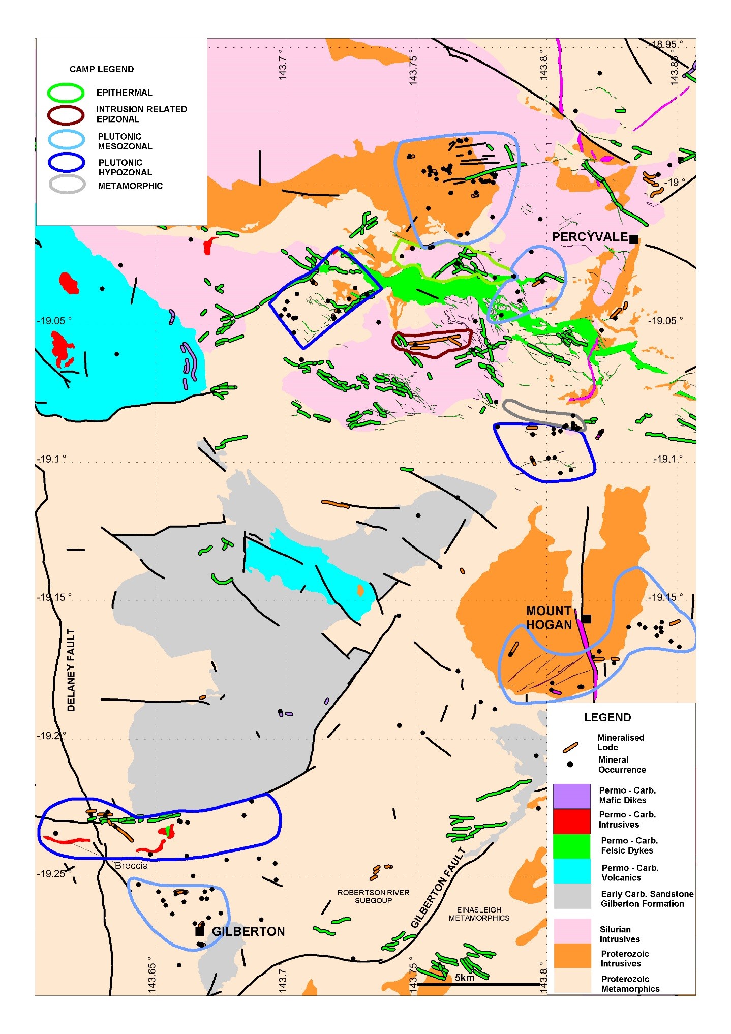
Basement rocks in the Gilberton District consist of variably deformed Proterozoic age metasediment of the Bernecker Creek, Daniel Creek and Corbett Formations and basic metavolcanics of the Dead Horse Metabasalt Member (Etheridge Group) (Figures 4 & 6). The sedimentary units are composed of mudstone, siltstone and sandstone grading into slate, phyllite, schist and gneiss. Numerous, extensive sills and dykes of Proterozoic age metadolerite and metagabbro (Cobbold Metadolerite) often 10’s to 100’s metres thick, have intruded the metasedimentary units. The regional scale NE striking Gilberton Fault marks the southeastern boundary of rocks of the Etheridge Group against amphibolite grade biotite gneiss of the Early Proterozoic Einasleigh Metamorphics (Figures 14 & 15).
Northeast of Gilberton in the Mount Hogan and Percyvale areas mid-late Proterozoic granite (Mt Hogan & Digger Creek granite) and Siluro-Devonian granodiorite (Robin Hood Granodiorite) batholiths have intruded the basement rocks. Throughout the district, irregular dykes and stocks of ENE trending Permo-Carboniferous age rhyolite intrude the Proterozoic and Devonian rock units (Figure 16).
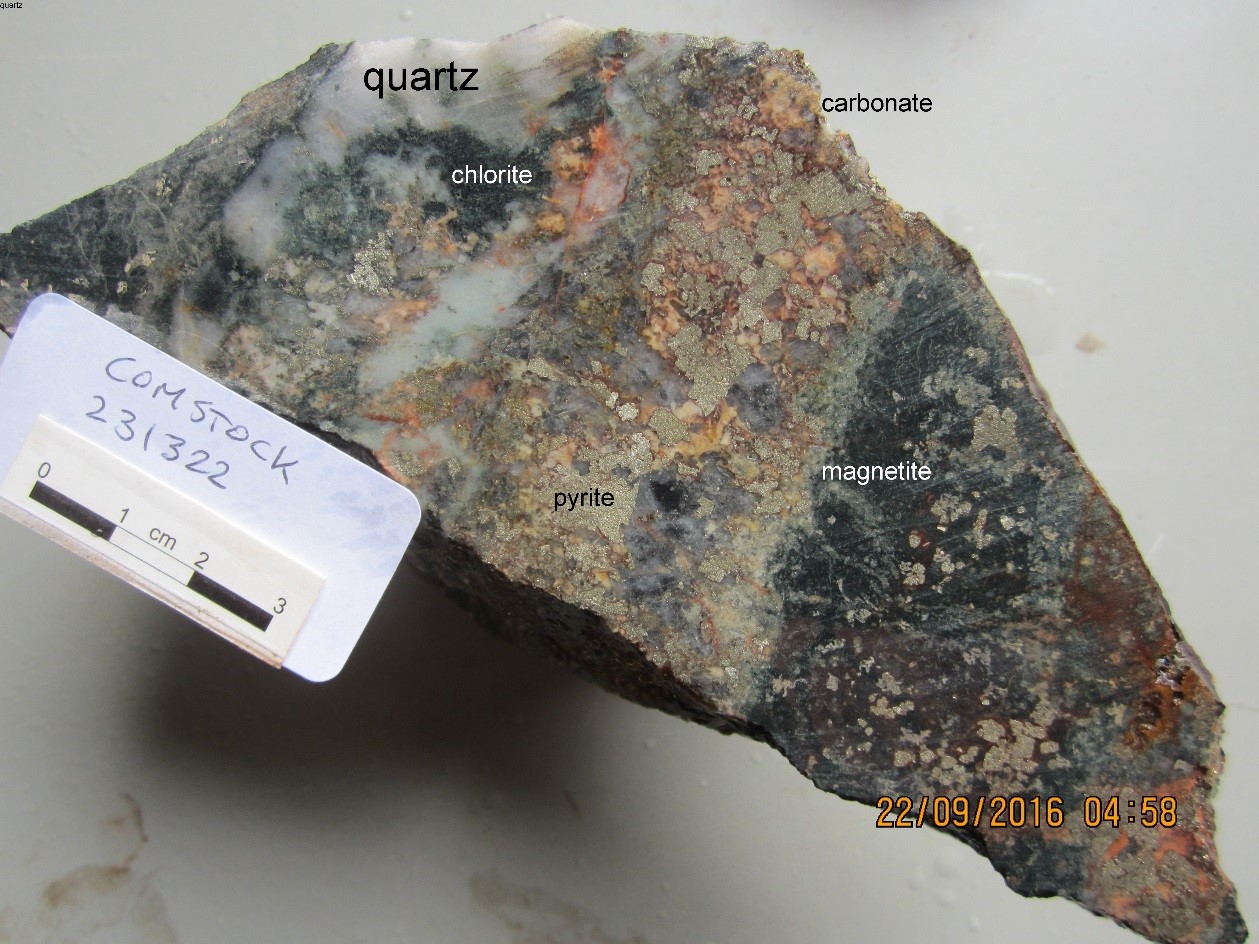
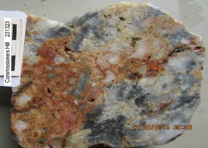
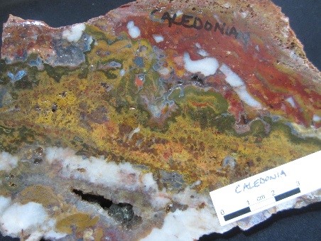
Mineralisation in the Gilberton and Black Knob camps typically consist of gold bearing quartz veins and silicified breccia, with minor disseminated pyrite in the quartz, hosted along single or sets of narrow (<2m) steeply dipping shears. The mineralised shears generally parallel the regional foliation but in some deposits cut oblique to the layering e.g. Commissioner Hill and Oratava (Figure 14). Comstock, the largest of the known gold deposits at Gilberton, consists of a broad, linear, northeast striking, steep northwest dipping zone of breccia, cemented and replaced by buck quartz, iron carbonate, magnetite and pyrite. Deposits partially hosted in metadolerite commonly possess iron carbonate (siderite?) as part of the infill and alteration products e.g. Comstock, Caledonia, Macedonia (Plates 22 & 23).
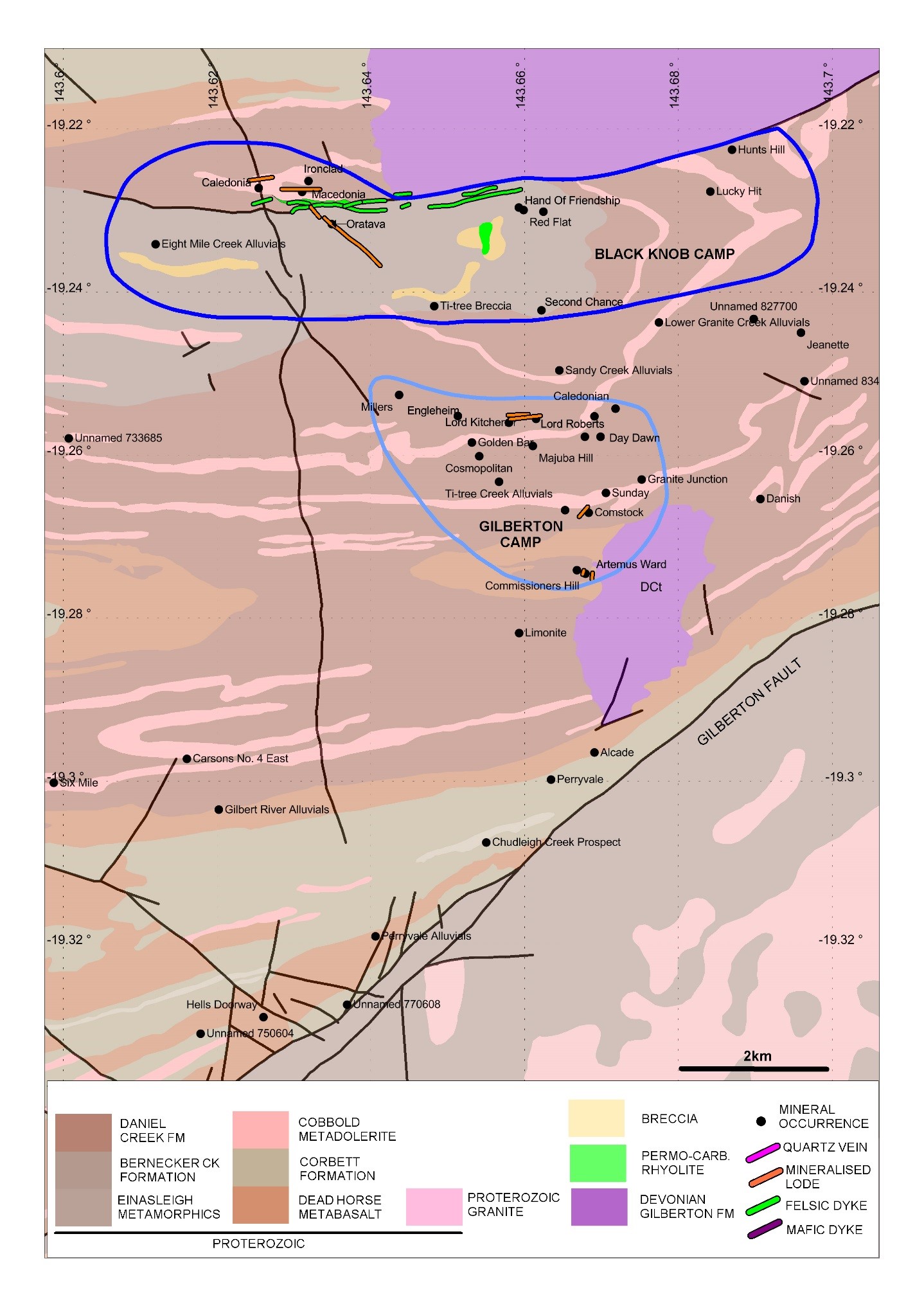
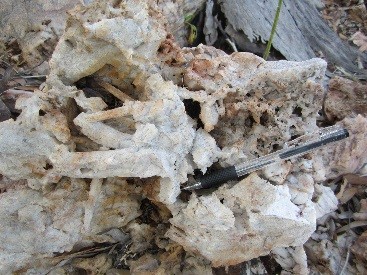
Quartz textures in the mineralised structures often reflect multiple episodes of fault movement. Early quartz phases are typically medium grained, white euhedral buck that have been brecciated and recrystallised with finer quartz and sulphide cross-cutting, infilling and/or replacing more fractured portions of the early vein material (Plate 24). At the Caledonia prospect early white, euhedral buck quartz has been brecciated and cemented by colloform banded and moss textured quartz and siderite (Plate 23). This indicates that the early plutonic style mineralisation has been overprinted by an epithermal event that could be related to the Permo-Carboniferous age rhyolite dyke that parallels the Macedonia lode, 100m to the south (Figure 15). Early phases of coarse and medium euhedral quartz crystals were observed at the Lord Kitchener and Caledonia workings (Plate 25).
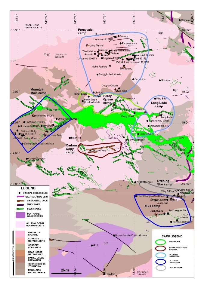
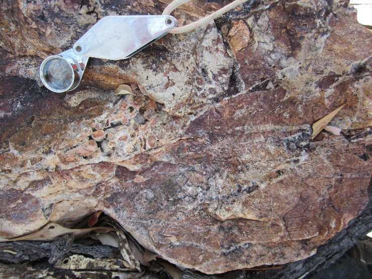
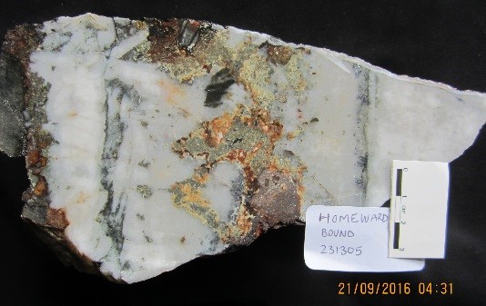
In the northern camps of the Gilberton district, two main styles of veining were observed: (i) south to southwest shallow dipping, coarse to medium grained, euhedral buck quartz sometimes cut by finer comb quartz, often lightly brecciated and infilled with sulphide minerals such as pyrite, chalcopyrite, galena, and minor sphalerite (e.g., Mt Hogan, Josephine, Homeward Bound, Mountain Maid), and (ii): E-W trending, steeply dipping sericite-altered and variably silicified rhyolite breccias overprinted by thin (1-3mm) quartz stockwork veins composed of fine comb quartz and ultrafine sulphides (e.g., Percy Queen, Percy West, ZZ) (Plates 17, 26, 27 & 28) (Figure 16). Textural characteristics of the euhedral buck quartz suggest a hypozonal to mesozonal plutonic environment whereas the quartz textures in the rhyolite breccia and stockwork indicate an intrusive epizonal environment of formation.
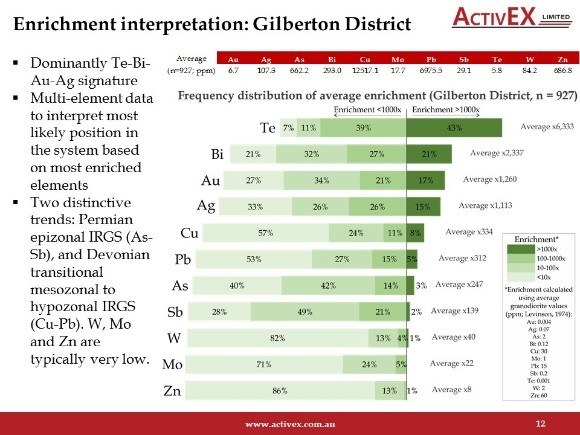
Geochemical sampling throughout the Gilberton district, including the Mount Hogan and Percyvale areas identified geochemical zonation at the camp and deposit scale. Extensive multi-element assaying by Activex Ltd (2015 – 2017) has identified distinctive signatures (Figure 17). Most samples collected from known mineral occurrences are enriched in tellurium and bismuth indicating a magmatic input to the mineralising solutions. The Devonian age plutonic style, mesozonal to hypozonal deposits are typically enriched in copper and lead whereas Permian age epizonal IRGS deposits have a characteristic arsenic- antimony signature. Understanding these geochemical variations is important when designing exploration programmes that target specific styles or ages of mineralisation and interpretation of results.
9.5 KIDSTON INTRUSIVE RELATED MESOZONAL BRECCIA HOSTED GOLD DEPOSIT
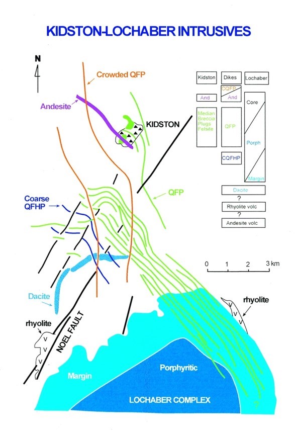
The Kidston gold mine is located 280kms NW of Townsville and 40 kms south of Einasleigh. Between 1985 and 2001, 109 million tonnes of ore were treated and around five million ounces (158 tonnes) of gold recovered (Figures 1 & 6). The deposit lies along the northwest trend of a rhyolite dyke swarm that emanates from the Lochaber Ring Complex 5km to the south and extends to the Newcastle Range Volcanics 25km to the northwest (Figure 18). Radiometric dating of granite at the Lochaber Ring Complex, volcanics in the Newcastle Range and pre and post mineralisation dykes at Kidston all return an early Carboniferous age (330-335 Ma) (Murgulov et al, 2009). The dyke swarm is coincident with a regional gravity low extending to the Lochaber Ring Complex suggesting the area is underlain at depth by an early Carboniferous batholith.
Gold mineralisation occurs within a large ovoid shaped breccia pipe 1100m by 900m at surface and at least 1300m deep. The margins of the pipe dip steeply inward resembling a funnel. The breccia pipe is hosted in Proterozoic age migmatite of the Einasleigh Metamorphics. The pipe straddles the contact between granodiorite and banded biotite gneiss-amphibolite phases. Numerous pre-breccia and post breccia dykes and stocks of rhyolite, some restricted to within the margins of the breccia pipe have been mapped at surface and defined at depth by drilling (Figures 19 & 20). These host lithologies can be traced in the breccia mass through the pipe. In general, the breccia grades from more intensely milled, rounded clasts in a rock flour matrix at the core of the pipe to less milled, blocky breccia composed of angular clasts in a clast support fabric and open space matrix around the margins and at higher levels in the pipe. Zones of breccia within the pipe dominated by rhyolite clasts reflect the location of dykes and stocks prior to pipe formation.
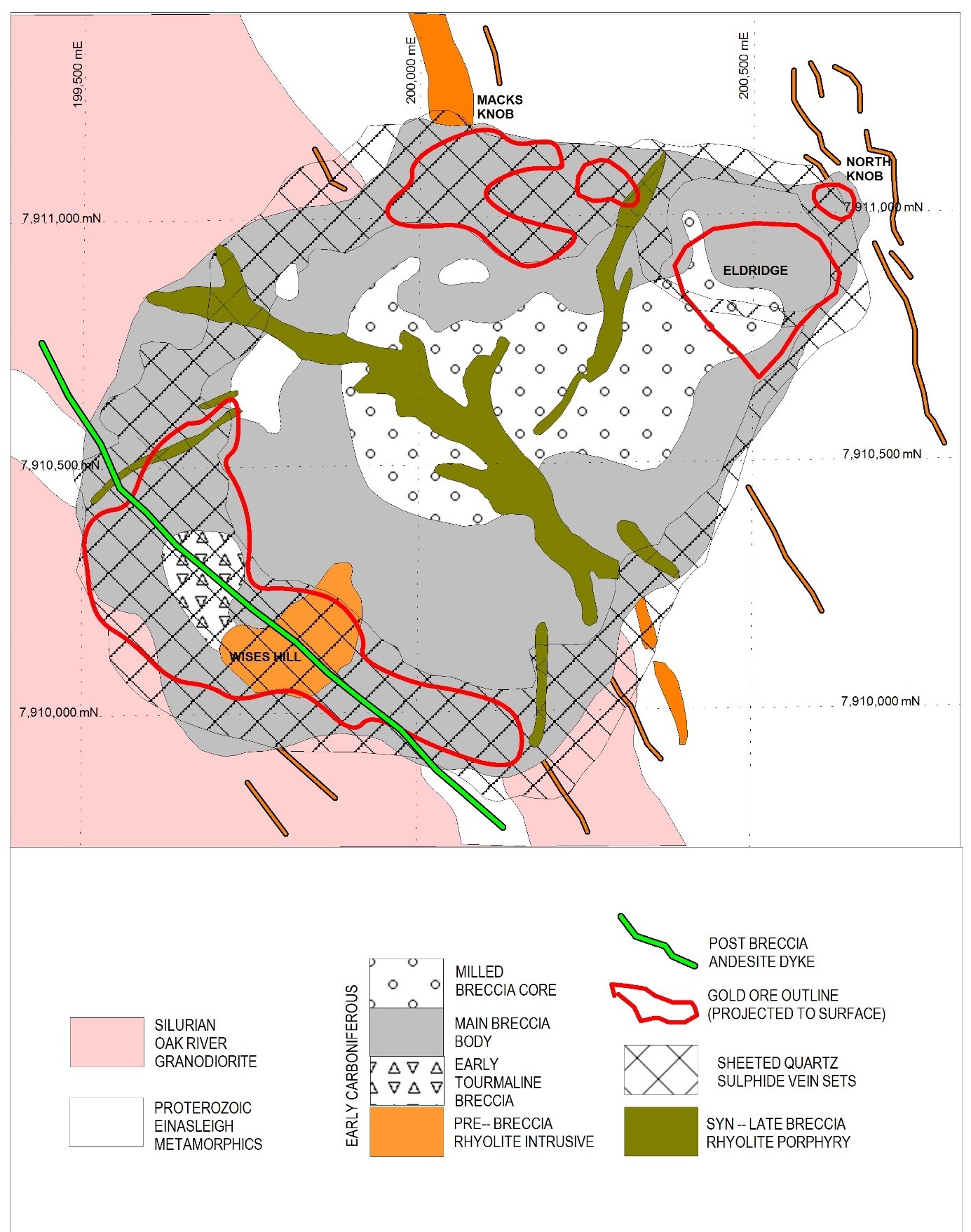
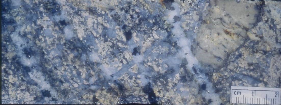
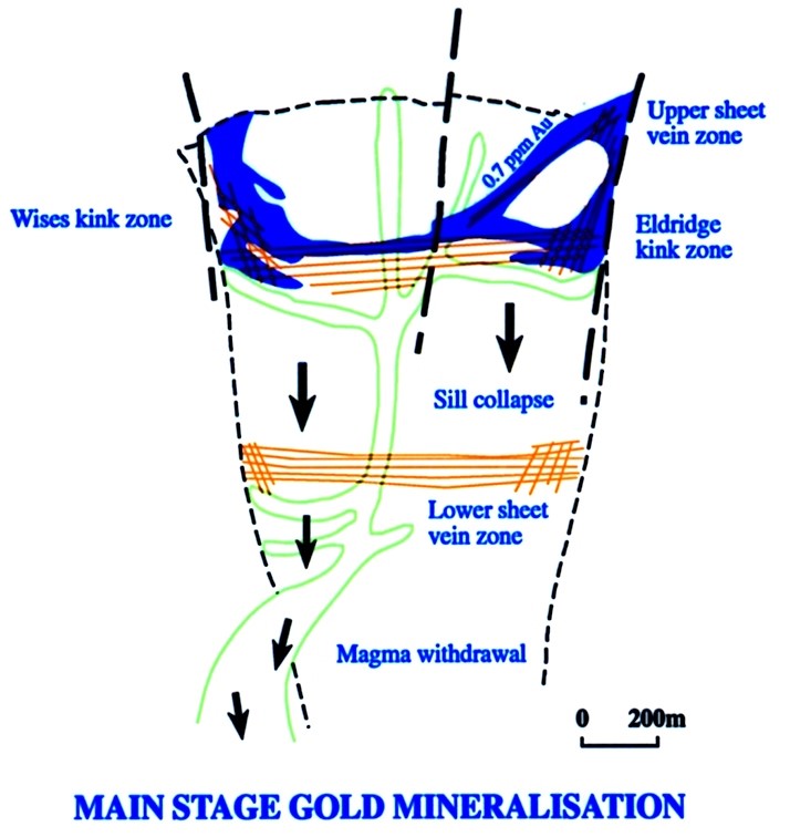
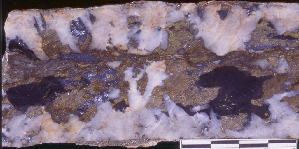
Mineralisation consists of medium grained comb quartz, carbonate and base metal sulphides as sheeted veins, breccia infill and replacement (Plates 29, 30a & b). Gold occurs as inclusions within the sulphides. Data from fluid inclusions indicates the pipe was formed around 3.5kms from surface (Baker & Andrew, 1991). This implies that the space required for the main breccia body to form must have been through magma withdrawal. A later stage of magma withdrawal was also probably responsible for collapse or sagging of the breccia pipe that produced bowl shaped extensional sheeted vein sets and opened fractures for intrusion of rhyolite porphyry sills cutting the main breccia. The main episode of gold mineralisation was related to this late stage collapse of the pipe (Figure 21).
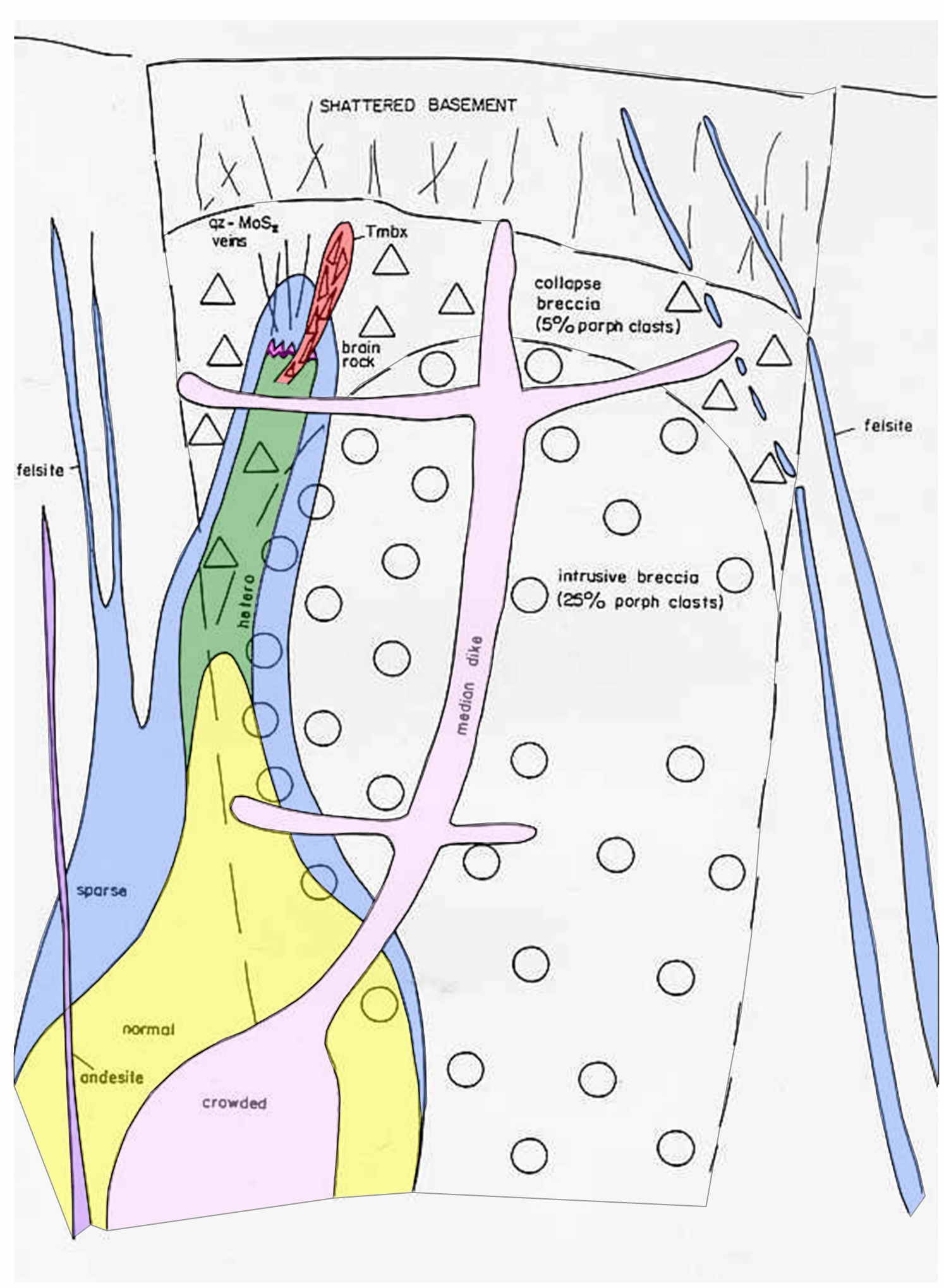
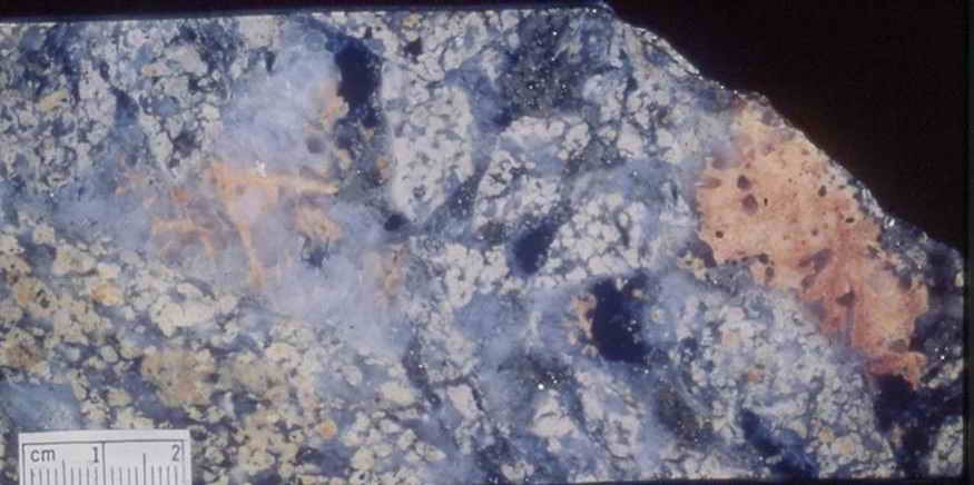
An early phase of quartz-molybdenite and quartz-magnetite stockworking and quartz-tourmaline breccia hosted in a porphyritic rhyolite stock was brecciated by the main pipe forming event and preserved as clasts in the southwest section of the pipe. Biotite and K-feldspar alteration was associated with this phase of mineralisation. Detailed studies on alteration and mineralisation has shown a complex zonation both laterally and vertically within the breccia pipe (Morrison et al, 1996; Morrison & Seed, 1993). Generally, the main breccia body and zones of sheeted veining possess a pervasive phyllic (quartz-sericite-pyrite-carbonate+/-chlorite) style of alteration. In deeper levels of the pipe an earlier biotite-epidote-magnetite-potassium feldspar is typically overprinted by the phyllic alteration assemblage.
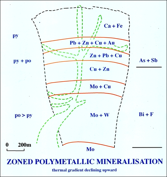
A study of metal zoning at Kidston shows that apart from the gold and base metal sulphides in steep dipping sheeted veins overlapping the margin of the pipe at surface the core of the pipe at surface is barren (Figure 21). Under the barren zone lies a 200-250m thick gold-base metal sulphide-pyrrhotite zone consisting of sheeted vein and secondary breccia infill mineralisation, then a zone of pyrrhotite-dominated (lesser base metal sulphides) cavity infill, and a lower sheeted vein zone hosting pyrrhotite, base metal sulphides, molybdenite, fluorite, native bismuth, tennantite, wolframite and scheelite. This zoning pattern is typical of a polymetallic porphyry system with a molybdenum core and is thought to reflect increasing temperature with depth (Morrison et al, 1996).
9.6 MOUNT TURNER
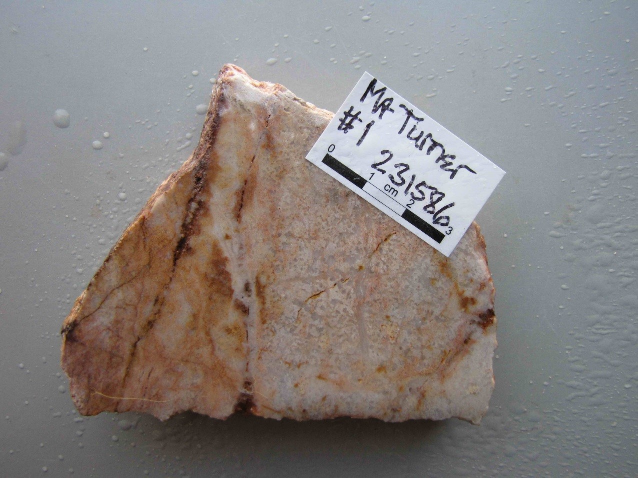
The Mount Turner intrusive complex is located 11kms NW of Georgetown and consists of multiple phases of rhyolite to microgranodiorite dykes, stocks and associated breccia, hosted in Proterozoic Forsayth Granite and metasediment of the Lane Creek Formation (Figures 6 and 22). The intrusive complex has been described as a porphyry Cu-Mo system with zoned polymetallic mineralisation (Baker & Horton, 1982). There is an early rhyolite phase of intrusion consisting of a central plug, a swarm of greisen-altered dikes and local breccias and copper mineralisation. A later phase of granodiorite plugs have Cu-Mo mineralised breccias and peripheral veins that zone from copper in the core through a barren pyrite zone to distal As-Pb-Zn-Ag-Au veins that were the main focus of historic mining (Plates 31 & 32).
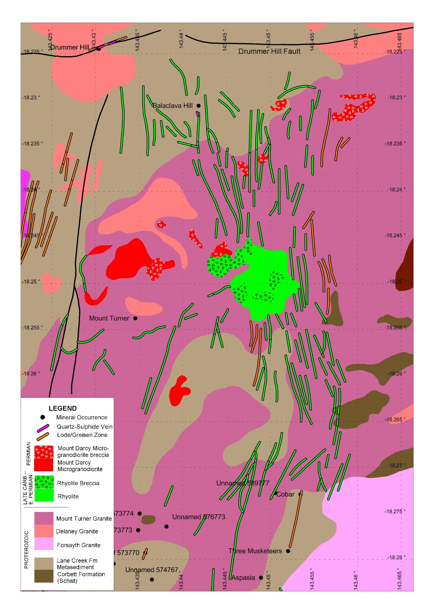
A review of the historic data and addition of radiometric dating and interpretation of multi-element geochemistry allows an interpretation of the mineralised system. The Mt Turner mineralised area is a 6km diameter magmatic-hydrothermal system with an early NNE-trending rhyolite dike swarm with potassic and sericitic alteration and Cu mineralisation. A second phase of intrusion is a widespread set of micro-granodiorite plugs with local dikes and breccias and potassic-sericitic alteration that coincide with all the significant prospects with Cu-Mo and As-Pb-Zn-Cu-Ag-Au veins.
The multi-element geochemistry demonstrates that the deposits are all part of the same system with an As-Bi-Te-Au-Ag-Cu-Pb-Zn signature and an inbuilt zoning pattern from Cu-Mo to Cu-As-Sb-Au-Bi to Pb-Zn-Ag-(Au) that is characteristic of the Permo-Carboniferous porphyry systems in the district and distinct from the nearby Early Devonian structure localised Drummer Hill Mine that has an As-Au-Ag-Pb signature.
There are three new radiometric ages from this mineralised complex that also bear on the mineral evolution (Table 4.1). The Rocky Reward Mine on the same structure as the Drummer Hill Mine returned a K-Ar age of 372Ma from sericite alteration and is interpreted as part of the Early Devonian (~400Ma) mineralisation event with a partial Carboniferous-Permian alteration overprint. The alteration at the Claymore deposit in the Four Grande area is 311Ma (Late Carboniferous) but the deposit is interpreted as part of the polymetallic mineralisation event and therefore more likely early Permian. The molybdenite at Mt Turner proper is 289.4Ma which is early Permian and therefore consistent with the model from drilling by Kidston Gold Mines that the Cu-Mo mineralisation is related to the Mt Darcy Micro-granodiorite suite. Although the paragenetic relations between the rhyolite system and the granodiorite system seem well established the dating is not entirely clear.
9.7 HUONFELS, INTRUSION RELATED EPIZONAL LODE AG – AU PROSPECT
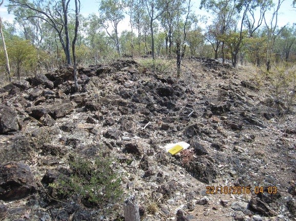
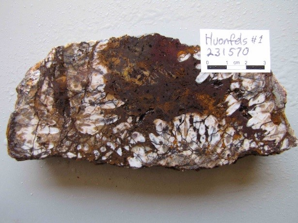
The Huonfels prospect is located 33kms NW of Georgetown and is hosted in Proterozoic metasediments (Lane Creek Formation) and porphyritic biotite granite (Forsayth Granite) and Carboniferous rhyolite intrusions (Huonfels Rhyolite Member, Dismal Creek Dacite) (Figure 6). The prospect lies between the Permo-Carboniferous Dismal Creek and Maureen volcanic centres. Mineralisation at Huonfels is related to a northerly trending zone of steeply dipping, anastomosing faults 4.5kms long and up to 1km wide. Irregular and discontinuous zones (up to 20m wide) of ferruginous and silicified breccia and quartz veining are localised along the structures (Figure 24; Plate 33). Quartz veins rarely exceed 20cm in width and like the breccia infill are composed of medium to fine grained euhedral quartz crystals and less commonly chalcedony (Plate 34). Rocks adjacent to the mineralised structures are often intensely replaced by quartz, sericite and iron carbonate. Pyrite, galena and arsenopyrite are commonly disseminated throughout the silicified rocks and as late stage breccia infill.
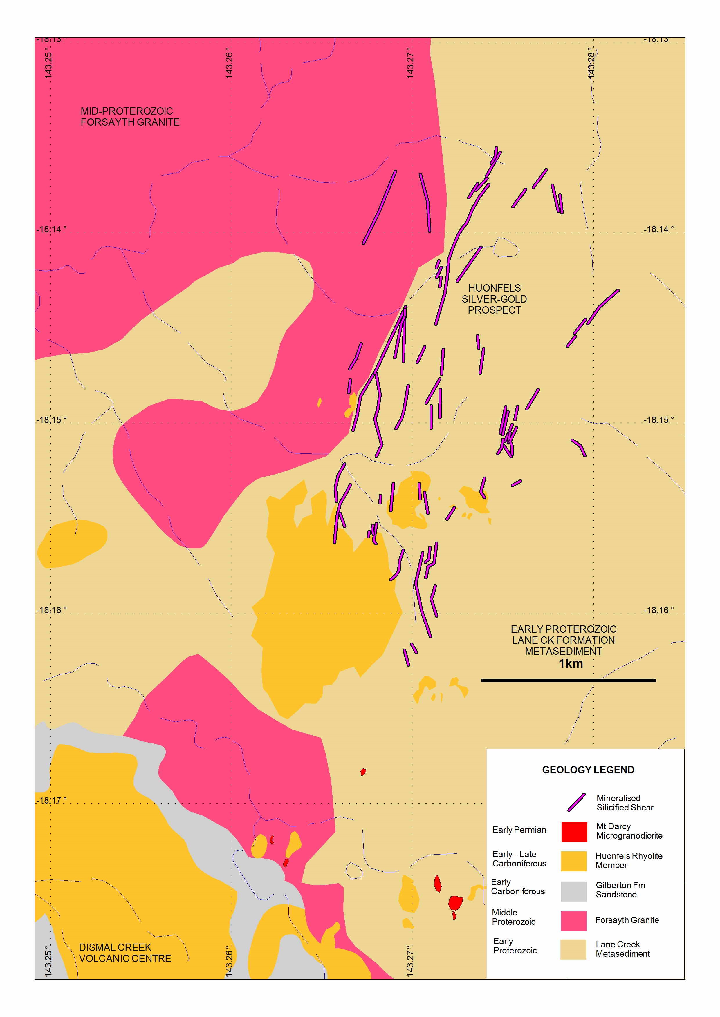
From 1985 to 1990 CRA conducted rock chip sampling, mapping, trenching, geophysics surveys and drilling over the Huonfels Prospect. Drilling confirmed the broad zone of faulting that marks a contact between metasediment (east) and granite (west). Numerous dykes and intrusions of rhyolite, often brecciated and altered were mapped on surface. The best intercept in drilling was 6m @ 2.56g/t Au and 527g/t Ag (RC85KA4). Examination of multi-element geochemistry from Huonfels shows that silver is much more enriched than gold, arsenic and antimony is dominant over base metals and tellurium is significantly enriched. The structural setting, nature of the mineralised quartz and geochemical signature all point to Huonfels being a distal, epizonal intrusion-related lode style deposit. The geochemical signature is similar to other nearby Permian and Carboniferous intrusion-related deposits such as Phyllis May, Log Creek and Ironhurst that also have enrichment of silver over gold.
No dating has been completed on the intrusions or alteration at Huonfels. It is inferred that Huonfels is early Permian as it is part of the same intrusion and mineralisation suite as Ironhurst on which there is a sericite K-Ar date of 278Ma and the Mt Darcy Micro-granodiorite where there is a sericite K-Ar age of 285Ma (Table 4.1, Figures 6 & 8).
9.8 AGATE CREEK EPITHERMAL GOLD DEPOSIT
The Agate Creek gold deposit is located 340km west of Townsville, 45km south of Forsayth and 65km west of the Kidston gold mine (Figures 1 & 6). Laneway Resources Ltd plans to develop the deposit in 2018. The main part of the deposit, known as Sherwood contains the bulk of the defined gold resources (4.39 Mt @ 1.47 g/t for 207,000 ounces). Gold resources at Sherwood West have been calculated at 4.78Mt @ 1.25 g/t for 194,000 oz using a 0.5 g/t cut-off (Renison Consolidated Annual Report, 2012).
The Agate Creek Camp lies adjacent to the regional scale Robertson Fault Zone and off the northwest end of the Agate Creek Volcanic Complex. The basement rocks are Proterozoic metasediment, composed of mudstone, sandstone, phyllite, quartzite and meta-basalt. The metamorphic rocks have been intruded by Siluro-Devonian age Robin Hood Granodiorite and by early Permian rhyolitic and andesitic dykes and stocks that are related to the Agate Creek Volcanic Complex. The volcanic complex is largely fault bound and consists of andesitic lavas, rhyolitic tuff and ignimbrite. Jurassic Hampstead Sandstone consisting of basal conglomerate and quartzose sandstone forms plateau-like outliers capping the older rocks (Figure 25).
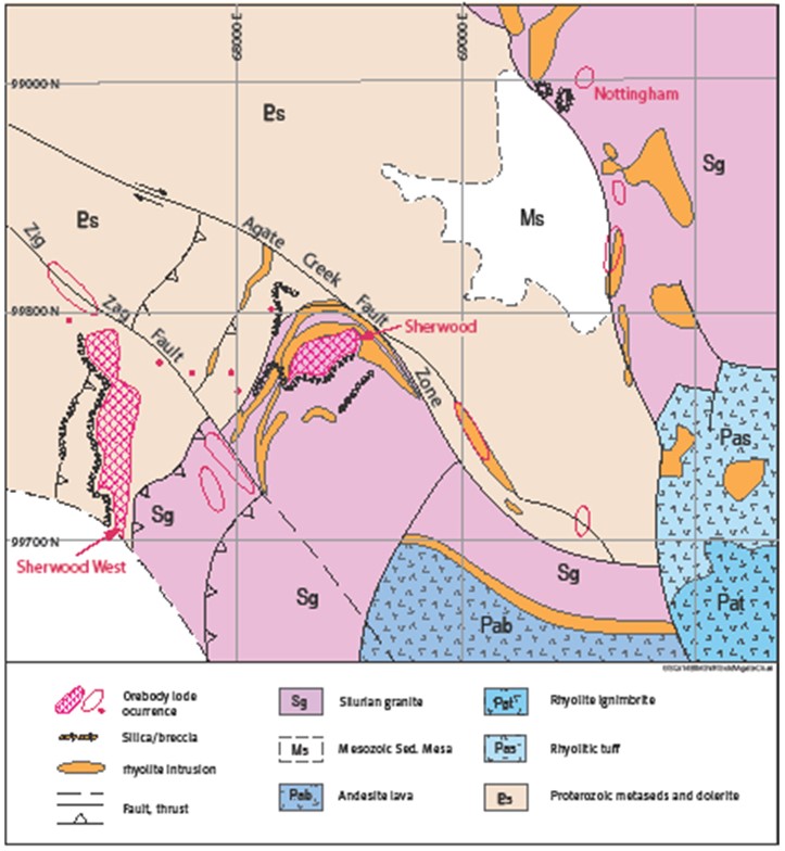
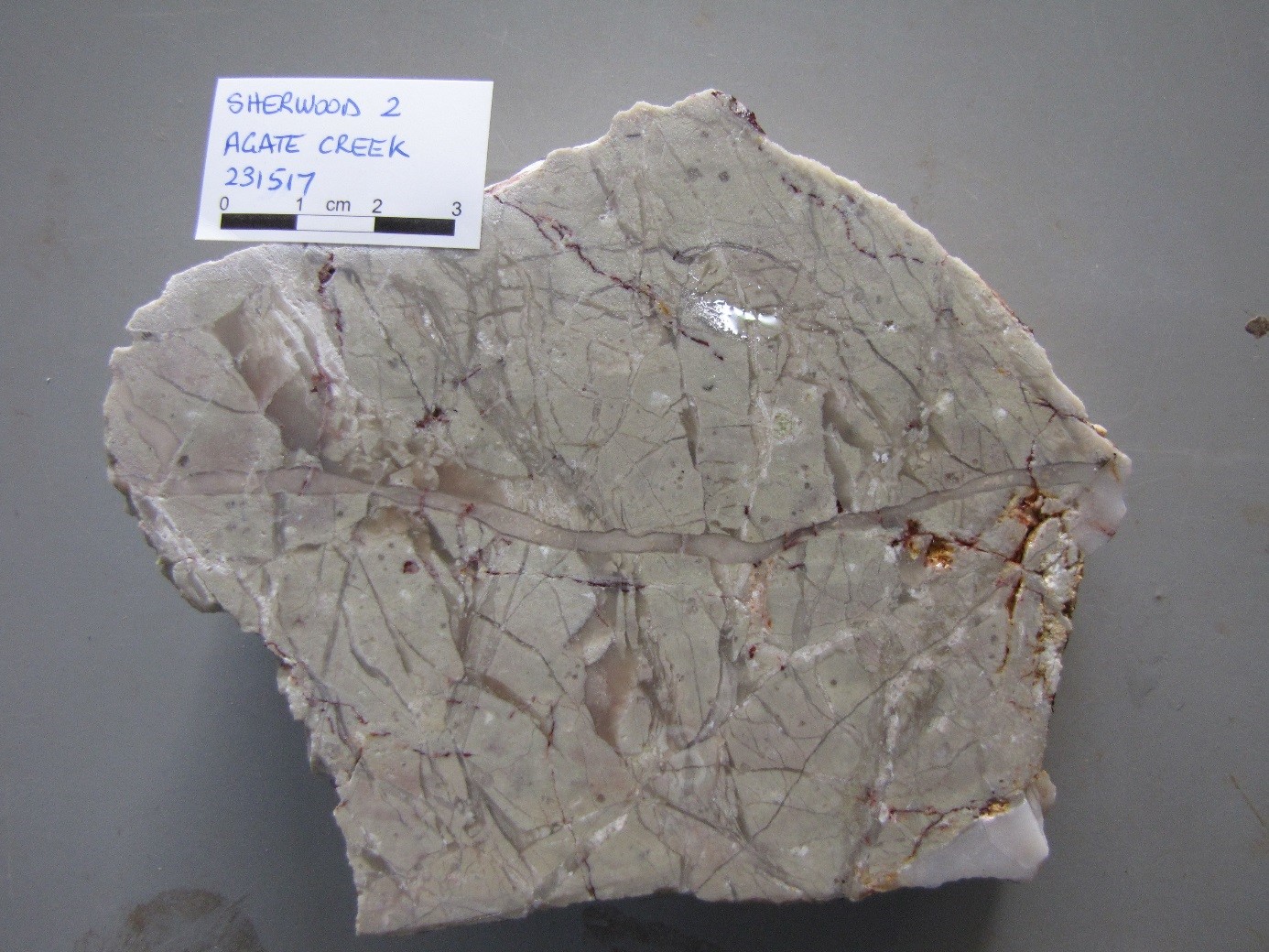
The mineralisation at the main Sherwood deposit is best developed in breccias and vein networks hosted in shallow dipping rhyolite dykes that occupy shallow SE-dipping thrust faults in the granodiorite. Thrust faults also separate the granodiorite from the metamorphic rocks throughout the prospect area and there are series of N & NW-trending steep normal faults that bound and disrupt the mineralised zones (Figures 25 & 26). Mineralisation is characterised by irregular swarms of narrow colloform banded chalcedonic veins which grade into breccias and stockwork vein zones (Plates 16 & 35). They have a geochemical signature (Au As Sb Ag Te) which is typical of distal epithermal mineralisation with a possible link to andesitic intrusions indicated by the Te enrichment. Rhyolite dykes associated with mineralisation have returned U-Pb zircon ages of 285 Ma (Early Permian) (Cross et al, in prep) and are interpreted as part of the adjacent Agate Creek Volcanic Complex.
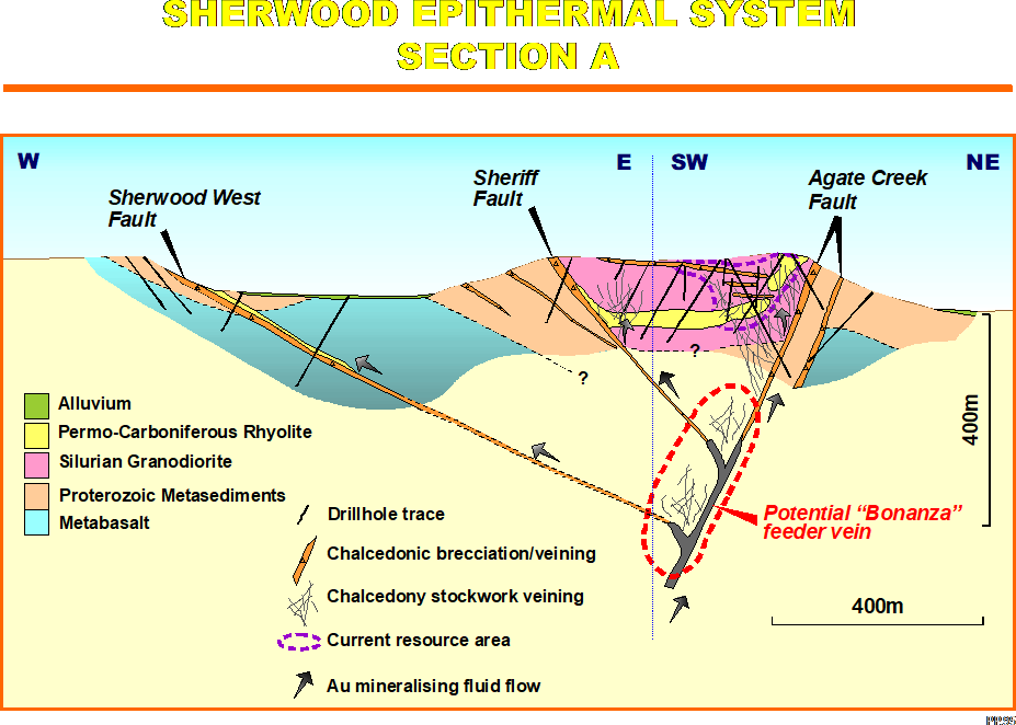
At the Sherwood West resource, gold mineralisation is localised along a North striking fault, that dips 30° to 45° East. The Sherwood West Fault hosts a zone of chalcedonic veins and breccia 5 to 10m thick, hosted in metasediment. Permian rhyolite and quartz-feldspar porphyry dykes that have intruded along the fault are also mineralised. This mineralisation overall and the ore controls are very similar to the Sherwood deposit.
The epithermal mineralisation at Agate Creek is part of a group of similar deposits localised in a Permian NW-SE rectilinear fault network occupied by dikes and volcanic complexes (Figure 3). The known deposits have been interpreted as linked to each by a series of dikes in faults and to emanate from a bonanza zone lying on a major fault (Figure 26). Drilling in the Agate Creek Fault Zone which was the interpreted feeder demonstrated mostly post-mineralisation movement Modelling of the alteration zoning by company consultants suggest the feeder zone may be SE of the known mineralisation.
